

Remote sensing is now one of the greatest essential technologies for collecting data directly from the earth efficiently. Remote sensing techniques are becoming incredibly valuable in several research aspects of everyday life, thanks to the advancement of ecological information science. These include atmospheric physics, ecology, soil and water pollution, soil science, geology, volcanic eruptions, and the earth’s evolution.
This article provides a complete picture of writing the best Remote Sensing thesis. Let us now start with the features of Remote Sensing
Characteristics of Remote Sensing
The following are the major characteristic features of Remote Sensing mechanisms
- Angle of view and capture time
- Radiation type which includes infrared radiation, visible light, and radar
- Sensor stage like ground, satellite and so on
These features can be used in multiple cases which also have the potential to be reused. At the Remote Sensing thesis, we provide detailed practical explanations on all Remote Sensing features including recent advancements. Reach out to our website to see the descriptions of the characteristics mentioned above. Let us now look into the remote sensing uses,
Uses of Remote Sensing
Remote Sensing is used for gathering information and it is also used for the following purposes
- Real-time monitoring
- Precision in navigation
- Remote Sensing through aerial and satellite imaging
- Variable rate technology
- Direct sensing using Veris end EM 38
Also, the applications of remote sensing are not confined to this list. The specific uses of Remote sensing applications can be broadly grouped into some important categories as stated below
- Hydrological applications– include agro hydrology, water, and energy balance analysis
- Biological and conservative applications– mapping and monitoring of vegetation, deforestation, and reforestation methods. It also finds huge application in controlling forest fires another forest inventory
- Physical planning and land surveyingapplications – Remote Sensing is highly important in planning for physical scenarios and land surveying purposes which include a collection of data on topography, GIS, and spatial data
- Meteorological applications– for climate change and global warming studies and especially in weather forecasting
- Environmental studies and soil mapping applications– causes and effects of different kinds of pollution, use of agricultural land, erosion, soil degradation along with a detailed survey on soil mapping and management of water can be studied using Remote Sensing
Many research labs across the world use authentic reports from major satellites as a result of remote sensing. We have also got tie-ups with top space research centres of the globe to help our customers with the most relevant and recent data for their research work. So get in touch with us to know more about our services. Let us now talk about the constraints associated with remote sensing
Limitations of remote sensing
The following are the major limitations of Remote sensing applications
- Multiple passes irradiance changes and cloud interference effects
- Troubles in getting the images at times of demands
- The cost of operation is very high concerning one square kilometer
- Spatial resolution is coarse
- Old satellite platform coverage is repeated and infrequent
- Duration for turnaround is slow because of corrections, calibrations, geo rectification in image processing
Overcoming such limitations is the scope of both present and future research in Remote Sensing. For innovative ideas for your Remote Sensing Thesis, you can contact us at any time. Let us now see how the Remote Sensing sensors are classified
Classifications of Remote sensing sensors
The sensors that are used in Remote Sensing systems are classified on a different basis as given below
- Based on Application
- Images and mappers
- Prolifers, spectrometers, and radiometers
- Radar, Sonar and side scan Sonar
- Multispectral array and photographic film
- LIDAR, SLAR, and SAR
- Based on Wavelength
- Sound, micro, and seismic waves
- Emitted TIR and reflected NIR
- VIS array and film
- Based on Modes
- Active mode application using LIDAR, Radar and Sonar
- Passive mode application including VIS, IR, and Microwave
You can opt to choose one or more sensors depending on the objective of your research. Talk to our technical team and gain their experience in using various sensors. This can surely help you out in choosing the best one for your project. Let us now look into the composition of the Remote Sensing System.
What are the five main components of the Remote Sensing System?
- Illumination and source of energy
- Target interaction
- Transmitting receiving and processing data
- Sensor Energy recording
- Analysing and interpreting data
With these fundamental components, Remote Sensing System functions efficiently. What are the advantages of remote sensing? Let us now look into the merits of remote sensing below
- Covers large area including inaccessible places
- Repeated coverage for detection of changes
- Fast survey and increased accuracy
- Synoptic view can be achieved even in a cost-effective manner
- Multispectral data can be used for enhancing information in all weather and climate including precise operations at night
Beyond these aspects, remote sensing is used in many other advanced applications. To know all the potential and present-day applications of remote sensing reach out to us. By quoting successfully implemented projects we will provide an overall picture of all remote sensing uses. Let us now look into how Remote Sensing System functions.
Lifecycle of remote sensing
The lifecycle or functioning of all remote sensing applications can be classified based on the following heads
- Data collection phase
- The selections of topographic and open-source data available are the major assets of this phase. The following are the important aspects on which data are collected
- Monitoring crop condition and soil moisture content and sampling
- Data on weather prediction using Remote Sensing
- Mapping boundaries and yield monitoring
- Best scouting and testing irrigation methods
- Pre-processing stage
- Removal of noise and detecting plots are performed in this preprocessing phase which is also the future scope of research in Remote Sensing
- Metrics used in scoring
- Based on data collected and processed the following metrics are used for scoring and evaluating them
- Crop segmentation and scoring
- Credit metrics
- Analysis
- In this stage of analysis of data collected the following points can help you
- Variability and its possible causes have to be determined
- Variations in measured characteristics of crops and soil
- How registered variations impact crop quality and yield
- Decision making
- Finally the important part is the decision-making process for proper management
- Possibilities for mitigating and changing the variability
- Possibility of generating profits by adapting changes
- Methods to implement the suggested changes
- Impact on yield and quality
- Decisions on decreasing input
In all these steps various methods and algorithms are involved. We are here to give you complete support on writing protocols, checking algorithms, and successfully implementing the codes. You can get in touch with us for all your research needs. What are the top research areas in Remote Sensing?
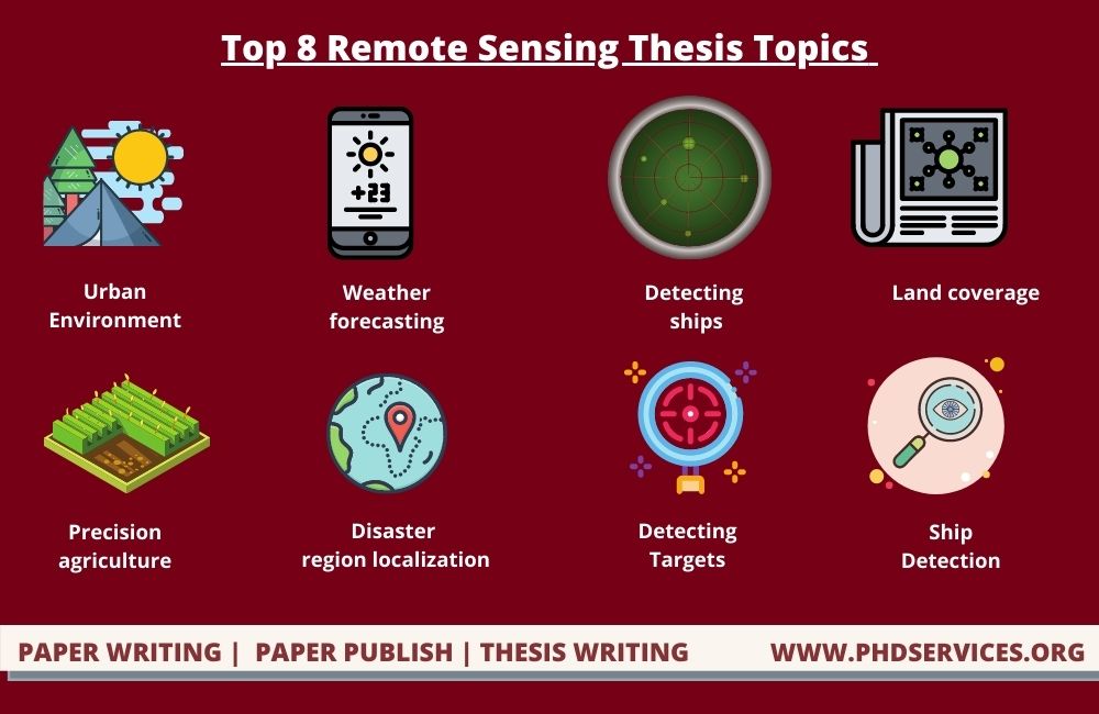
Top 8 Research Topics Remote Sensing Thesis
The following are the major and trending research topics in Remote Sensing
- Sustainable development of urban environment
- Advanced weather forecasting
- Classifying and detecting ships
- Classification of changes in land coverage and use
- Urban environment expansion and related issues
- Remote Sensing Precision agriculture
- Disaster region localization
- Detecting targets and classifying images
- Ship detection and classification
Currently, we are rendering thesis writing support on all the topics mentioned here. By providing references from authentic resources and benchmark research journals are here to help you out in writing the best Remote Sensing thesis. Consider the following three important trends as identified by our experts from the existing literature
- The assimilation of interconnected remote sensing imagery, predominantly for analyzing or designing urban areas as a complicated process
- The establishment of innovative algorithms for urban feature extraction
- The enhancement in the precision of standard algorithms based on the spectrum for dealing with these issues
A well-thought-out research strategy or thesis ensures that your procedures correspond to your research question and also that you utilize the appropriate type of study for your findings. For this purpose, you now must decide if you will use a qualitative or quantitative method.
What is the difference between qualitative and quantitative research approaches?
- Qualitative Approach
- Subjective experiences, concepts, and beliefs can be understood clearly
- Through this approach you can explore the most pressing research problems which are left unanswered
- As you can game deep knowledge about a specific topic you can easily create novel remote sensing project ideas
- Quantitative Approach
- Through this approach you can make verifications of various hypotheses and establish relationships among various variables
- You can make measurements of certain variables and give descriptions including correlations, average, and frequencies in your data
- Efficiency of a novel method, product, and program can be tested promptly
Therefore based on the needs of your research you can choose either of the two approaches or both of them. To give you more idea on these approaches, we have come up with a detailed note on its types below. The following are the two primary types of quantitative research designs
- Features, means, patterns, and connections among variables are investigated using correlational and description techniques
- To assess causal linkages, empirical and quasi-experimental techniques are being used
So experimentally to obtain precise scientific data you can opt to use quantitative approaches. While Qualitative research designs are more adaptable than quantitative research approaches
- Case studies, ethnographies, and grounded theory models are examples of qualitative designs
With a fast-growing amount of satellites in space and many scheduled for launching, as well as new devices for proximal sensing, the variety of mechanisms for creating remote sensing technology and data collection has expanded as well. In this regard let us now look into the latest technologies involved in Remote Sensing applications.
Latest technologies for Remote Sensing
- Multimodal imaging and unmanned aerial vehicles
- Terrestrial laser scanning or TLS
- Light detection and ranging or LIDAR in airborne applications
Our experts are well versed in using these technologies for real-time implementations. We have also rendered support to the research and development arms of prominent organizations and so we gained enough practical knowledge in the field of remote sensing thesis. Let us now look into the scope of remote sensing.
Current scope in remote sensing
- Thermal and optical-based features
- Machine learning and multi-temporal analysis
- Features based on SAR
Generally, we provide crucial technical data on all aspects of remote sensing to guide you in making the perfect project with vast scope for future development. All techniques and methods followed in Remote Sensing applications are explained with simple as well as with real-time examples. In this aspect let us now look into the different techniques in Remote Sensing,
Remote Sensing Methods and Techniques
The following methods are used for Remote Sensing purposes based on specific applications as listed below
- Accuracy assessment
- Advance the strategies for sampling
- Area comparison and direct visual assessment
- Confusion Matrix and Kappa statistics
- Detecting patterns
- Cross-correlation and classification based on objects
- Image differentiation and chemometric analysis
- Analyzing principal components and neural networks
- Fuzzy set theory
- Classification purposes
- Supervised and unsupervised learning
- Decision tree classifiers and fuzzy sets
- Data sets on multi-temporal applications and classifying neural networks
- Guided and contextual classification
- Auxiliary data usage
Our engineers will provide you with technical data on specific applications of Remote sensing methods and appropriate techniques used. This will provide you with enough support to rely on completely in your entire research journey. Let us now look into the ship detection workflow
Workflow for Ship Detection
You can detect objects like ships and can also determine the type of ship using Remote Sensing applications. The following is an example of shape detection workflow
- The obtained optical Remote Sensing images are at first sent for image pre-processing nodule
- In this phase sea-land segmentation and cloud filtering are performed
- For feature extraction, the data is then sent to ship candidate extraction phase
- Now the data is divided into two modules for identification and classification of ships
By this technique, the ships are both detected and classified efficiently. Feel free to have interaction with our technical experts on various other functions for which Remote Sensing systems were developed by us. Let us now have a look into the prominent tools used for designing such Remote Sensing Thesis Projects.

Simulation Tools for Remote Sensing
A remote sensing tool is a software program that processes and analyses satellite data. To analyze remote sensing data, there are numerous open and proprietary software available.
The following are examples of remote sensing application
- Hexagon geospatial ERDAS IMAGINE which is isolated from SG and Intergraph
- PCI Geomatica and IDRISI (Clark labs)
- eCognition (Trimble) and TNTmips (MicroImages)
- ENVI (Harris GeospatialSolutions) and RemoteView (Overwatch Textron systems)
- Dragon and ips (old and free remote sensing package)
The following is the list of open-source remote sensing software
- Sentinel Application Platform (European Space Agency)
- Opticks software and Orfeo toolbox
- TerraLook, ILWIS, GRASS GIS, and QGIS are the other important remote sensing capabilities
With the technical descriptions given by our experts on these tools, you can easily configure your Remote Sensing project to suit your objective. Also with our experienced and certified team of writers, we ensure to provide you ultimate expert assistance in writing your Remote Sensing Thesis. So you can confidently rely on us.